

Street names
Origin and meaning of the street names
Street names tell a story
It is part of human nature to give a fitting and distinctive name to one's own soil. The old, popular street names of Beckum describe the soil (Steinbrink), the location in the countryside (Wersedreisch) or in the city centre (Nordwall). Historical events (Sachsenstraße), important traffic routes (Münsterweg), trading places (Roggenmarkt) or simply the name of a resident (Lönkerstraße) are also reflected in street names.
Field names and squares
The names of fields, squares and paths are closely linked to the settlement history of a region and still provide an interesting insight into the peculiarities of the local past (Galgendreisch). While the field names designated one or more fields and were sufficient for a long time as a designation, the village community with its close coexistence required a parcelling of the inhabited area and thus also a division of the place and street names. Living space became even more cramped in the fortified towns of the High Middle Ages, where houses were also given their own name or later a house number.
Landmarks in the town
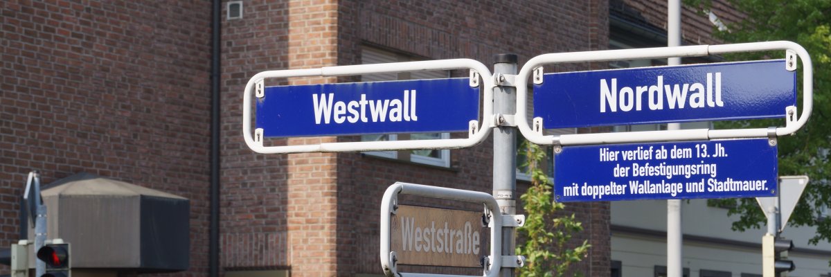
Many of the old street names only came into being after the town itself was founded and are of popular origin. They were not written on the corners of houses (because not everyone could read), but were passed down orally over generations. The location of the street could often be deduced from the context, as a "Westwall" was always located at the western end of the town and a "Windmühlenstraße" was probably close to a windmill that was visible from afar. This made it relatively easy to orientate oneself despite the narrow buildings within the city walls.
Changes due to language change
Colloquial usage sometimes changed or distorted the original meanings of the street names, some of which were lost completely. Another sometimes not insignificant intervention was the entry of the old names in the newly created land registers by the "correct" Prussian officials, who did not want to let some Low German names pass and invented a High German name for them according to law and order. As a result, the two Beckum squares in the north and west outside the old town wall, where markets were held and which were called Füör-Märkte (pre-markets) in Low German, suddenly became Feuer-Märkte (fire markets). They have survived to this day as Nordenfeuermarkt and Westenfeuermarkt.
New naming shows social change
While the street names in the centre are predominantly of old origin, there are some interesting names from the second half of the 19th century in the periphery that relate to the flourishing economy. These include Schlenkhoffsweg, Westfaliaweg, Ladestraße and, last but not least, Kalkstraße and Zementstraße. In recent times, when the demand for street names has increased immensely, we come across streets with the same names in many towns. Today, almost every larger town has its own "Vogelviertel" or "Baumviertel", sometimes even a smirking "Mädchenviertel" with Prudentia-, Gertruden-, Klara- and Marienstraße.
The municipal reorganisations carried out in many places also forced Beckum and Neubeckum to change historically established street names. A total of 43 duplicate and 10 similar street names had to be renamed during the merger. It was agreed to leave the street with the larger number of residents with its original name.
Political propaganda
It is not unusual for the names of streets and squares to also serve as political propaganda and are subject to renaming depending on the changing flag. Under the National Socialists, Oststraße became Ostmarkstraße, Nordring became Memelstraße, Lehmkühlchen became Horst-Wessel-Platz, Elisabethstraße became Saarlandstraße, Nordstraße became Adolf-Schürmann-Straße (Beckum's first Nazi member) and Alleestraße became Adolf-Hitler-Straße. Researching the old street names is therefore still an important contribution to the study of local history. As is so often the case, the truth is in the details.
Streets in Beckum
The year in brackets is the first official or presumed date of naming. Some names explain their meaning by themselves, for others a quick look in an encyclopaedia or a visit to our public libraries will help.
ABCDEFGHIJKLMNOP Q RST U VW X Y Z
Ahlener Straße (before 1806)
The street begins at Westenfeuermarkt and leads to Ahlen. It is called Ahlensche Straße in the original cadastral map of 1806.
Alleestraße (around 1900)
Lined alternately by red and hawthorn trees and more recently by Japanese ornamental cherry trees, this street, together with Sternstraße, encircles the old rampart gardens (see Nordwall). Under the National Socialists, it was called Adolf-Hitler-Straße.
Alsenstraße (around 1900)
Nothing further known.
Alter Hammweg (possibly 14th century)
Trade route to Hamm in the direction of the Lippe ford near Uentrop. Where it leaves the Beckumer Stadtfeld, the Hammwarte, similar to the Soestwarte (Höxberg), was a fortified point of the old land defence. After a new motorway was built to Dolberg in 1824 (today's Hammer Straße), the former route was given the name "Alt" (see "Auf dem Völker").
Alter Posthof (28 May 1946)
The square behind the town hall (Nordstraße 1) is a reminder of the former Samson'sche Posthalterei, whose postal service began in 1814 under the management of the postman, innkeeper and mayor Johann Heinrich Samson.
Altlomnitzer Straße (2009)
As a result of the Second World War, Altlomnitz, like almost all of Silesia, fell to Poland in 1945 and was renamed Stara Lomnica. The German population was expelled. Over 300 displaced persons came to Beckum. In 2002, a memorial stone to Altlomnica was unveiled in Westpark. To this day, the so-called Altlomnitzer Kirmes is an annual traditional gathering of the Altlomnitzer in Beckum.
Am Butterkamp (28.05.1946)
Kamp means enclosed arable or pasture land. The name can be interpreted popularly as a designation for a good cattle meadow, from which the cows gave particularly fatty milk. Butterkamp is mentioned as a field name in the cadastral map as early as 1831.
Am Flachsberg (2006)
This name is based on the existing field name Flachsberg.
Am Himmelreich (24.01.1958)
The name already appears in the land registers of the last century. It refers to higher areas and good soil conditions.
Am Hirschgraben (08.02.1928)
The low-lying wetland was formerly used as a horse pond and was still called Hersediek in 1441 or Am Herschteich in 1831. The Germanic word Hrossa or Hersa means horse. The Hersediek, literally horse pond, became the Hirschteich (deer pond) in later times.
Am Kollenbach (08.10.1937)
Originally part of the cement road. It was a wooded area called Kollenbusch or Am Kolmer. It was partly boggy and swampy and had several springs that merged further on to form the Werse. The name of the stream has always adapted linguistically: Kollenbach was called Wesebecke in 1439, Weesebecke around 1695, Colmersbeck around 1760, Colmarsbeck and Colmaringsbach around 1800, and Kolmerbach in 1806. The names indicate that it is the Kollenbergsbach. The name Kollenberg is already known around 1279.
Am Lippbach (30.03.1954)
The Lippbach is the third source river of the Werse. Around 1439 its upper course was called Spechtesbecke, around 1695 Spechtsbecke. The meadow and pasture area through which it flows in its upper course was still called Spechtskamp in 1957. The name Lippbach, which was not yet known at the end of the 18th century, refers to the old Lippweg, which led over the Lippberg and created the connection to Lippstadt.
Am Rüenkolk (06/04/1956)
Named after the stream of the same name, which flows into the Westteich. The cadastral map from 1831 calls the path "Am Rüren Kolchsgang" or "Rürenkolksgang". Rüeren or ruoren means to move violently, Kolk is the water hole. It was presumably a once vigorously swirling stream, which in dialectal simplification became Rüenkolk (Hundekolk).
An der Christuskirche
Named after the Protestant parish church built in 1884.
Annekestraße
Mathilde Franziska (3 April 1817 - 25 November 1884) was initially a writer of religious and literary works, published three almanacs with Low and High German literature (including by Annette von Droste Hülshoff), wrote poems, newspaper articles and a drama that was performed in Münster. She later joined the "Democratic Association", where she met her future husband Fritz Anneke. She wrote a book entitled "Das Weib im Conflict mit den socialen Verhältnissen" (Women in Conflict with Social Conditions) and fought for political and social equality. After emigrating to the USA, she published the "Deutsche Frauenzeitung" there from 1852 and founded the "Verband Deutscher Frauen" (Association of German Women). In 1865, she founded a German-language girls' school, which she ran for 17 years.
Anton-Schulte-Straße
Named after the Beckum local historian Anton Schulte (19 August 1905-18 August 1965), whose extensive studies led to the discovery of the Beckum princely tomb in 1959 (see Sachsenstraße).
Antoniusstrasse (around 1902)
Nordenfeuermarkt, now Marienplatz (see also these two names), was used as a cemetery from 1817 to 1843. St Anthony's Chapel stood there until 1906, and the nearby school was named after its patron saint in 1902. The path from the chapel to Linnenstraße was once popularly known as Kapellengang and was renamed Antoniusstraße. All that remains of the chapel is the ridge turret with the so-called "Swine-Tüns" (town museum).
On the Jacob (05.08.1954)
Nothing further known.
Auf dem Völker (30 March 1954)
In 1477, the field is described as follows: "by dem Hammweghe, geheten die Völker". Other mentions include "de Volker by dem Hammwege" in 1480, "up den Volcker" in 1511, "up dem Voelcker" in 1521 and "auf'm Völker" in 1831.
On the ramparts
deposits of dewy rock from quarries resulted in a hilly, undulating terrain.
Auf Sonnenschein (11 February 1949)
In 1873, the company "Sonnenschein & Co." built 6 lime kilns near Stromberger Straße.
Augustastrasse
Named after the "Augusta-Victoria AG" cement works, which was started in 1912. It was never put into operation and remained a shell, as the operating company went bankrupt in 1914.
Augustin-Wibbelt-Straße (27.08.1953)
The priest and dialect poet Augustin Wibbelt was born in 1862 on a farm near Vorhelm. After pastoring in various places, including Duisburg, he returned to his parents' farm in Vorhelm in 1935, where he died in 1947 (see also Wagenfeldstraße).
Benno-Happe-Weg
Low German poet, born on 19 March 1880 in Beckum. Happe grew up here, became a postal worker in Coesfeld, Tecklenburg, Senden and Münster, among other places. He died in Münster on 1 July 1978.
Bergstraße
At the place where Bergstraße once met the town wall was the Lütke (small) Windmühlenberg with the mill of the same name. It stood on the elevation of a plot of land that is still visible today, in order to get out of the lee of the town wall.
Bonhoefferweg (20.12.1984)
Named after the Protestant theologian Dietrich Bonhoeffer (born 4.2.1906 in Breslau). Bonhoeffer had been director of the Confessing Church's preacher seminary since 1935 and was executed in Flossenbürg concentration camp at the end of the war on 9.4.1945.
Borggrevestraße
Between 1861 and 1863, the building councillor F. A. Borggreve (died 1891) uncovered a burial ground from the 6th century in the south of the city (see Frankenstraße).
Brinkmannstraße (16 May 1949)
Johann Bernhard Brinkmann (1813 in Everswinkel - 1889 in Münster) worked as a chaplain in Beckum from 1839 to 1853 and was later Bishop of Münster. He was a close friend of Wilhelm Emanuel von Ketteler (see Kettelerstraße) and supported him in the construction of the hospital in Beckum, the former Vinzenzhaus on Südstraße. His memorial stone is located next to the west portal of St Stephen's Church.
Bruchstraße
Former quarry site.
Christine-Koch-Straße
Village landlady in Bracht, Sauerland dialect poet, awarded the Claus Groth Prize, lyricist (23 April 1869 to 3 April 1951)
Clemens-August-Straße (16 May 1946)
The street is named after Cardinal Clemens August Graf von Galen (1878-1946), who was also known as the "Lion of Münster" because of his courage in the face of the National Socialists (see Graf-Galen-Straße). The former Kolpingstraße, part of the so-called Kleine Oststraße, received its name on 26 July 1928 and was named after Adolf Kolping (1813-1865), the founder of the Catholic journeymen's associations. The current Clemens-August-Straße from the corner of Südstraße/Elisabethstraße to Kolpingstraße was called "Sommerstraße" for a time before it became Clemens-August-Straße at the same time as the NS streets were renamed. There is a bust of Cardinal von Galen on the corner of Everkeweg/Paterweg. It was commissioned by Johannes Greiwe and Georg Rottmann from Heinrich Gerhard Bücker and erected in the mid-1960s.
Dalmerweg
It leads to the farming community of Dalmer, which was already known as "Dalahem" in the 9th century. The owner of the main farm in this farming community was called "Schulte to Dalhem". "Dala" or "Dal" means valley, "hem" is synonymous with home or village. Thus "Dalahem" means the home or settlement in the valley. The street has been called "Dahlmerweg" since 1831.
Dechant-Schepers-Straße
Dechant Schepers (1870 to 1946) was the parish dean in Beckum. Among other things, he built the Liebfrauenkirche, the Marienstift, the Prudentiaschule and the Unterbergkapelle in Beckum. He also rebuilt St Elisabeth's Hospital twice, expanded the cemetery and created the Stations of the Cross in the cemetery.
Droste-Hülshoff-Straße
Named after the Westphalian poet Anna Elisabeth Freiin von Droste Hülshoff (1797 at Hülshoff Castle near Münster until 1848 at Meersburg Castle on Lake Constance).
Dr. Lönne-Straße (30.03.1954)
Sanitätsrat Dr. Lönne (1845 in Diestedde until 1903 in Beckum) was a popular doctor who was able to help numerous patients through his humour alone. He treated poor people and families with many children free of charge and is said to have even given them presents from time to time.
Dr.-Max-Hagedorn-Straße
Dr Max Hagedorn (26 April 1905 to 24 December 1998) assumed the office of mayor on 11 January 1946 and thus responsibility for the town of Beckum and its citizens at an extremely difficult time. Dr Max Hagedorn's tireless commitment to the common good earned him a high level of recognition among the population. A high level of personal commitment, expertise and his friendly and modest manner characterised him during his 24 years as mayor. Under the chairmanship of Dr Max Hagedorn, the Beckum town council set decisive priorities for the positive development of the town after the Second World War. Dr Max Hagedorn was particularly committed to the improvement of road conditions, development measures in the urban area and the creation of the first land use plan in 1958. He was involved in many subsequent development plans and was personally involved in the procurement of housing for displaced persons, refugees and evacuees. Dr Max Hagedorn saw his office as mayor as a service for the benefit of all citizens across party lines. On 21 April 1971, he was awarded the Federal Cross of Merit 1st Class of the Order of Merit of the Federal Republic of Germany by the Federal President. On 26 March 1974, he was awarded honorary citizenship of the town of Beckum.
Dyckerhoffstraße
Named after Dyckerhoff AG, which in 1931 took over the cement plants of the Wicking Group in addition to its own (see Wickingstraße).
Elisabethstraße
Saint Elisabeth (1207 to 1231), patroness of the hospital built in 1902 (first hospital founded in 1848).
Elisabeth-Wibbelt-Straße
Elisabeth Wibbelt, (21 January 1856 to 16 May 1911) born in Vorhelm, is the eldest sister of the Low German local poet Augustin Wibbelt. She wrote rapturous nature and love poetry, atmospheric, often simple images that evoke the longing for home, closeness, security and fulfilment. She later added numerous spiritual songs. Some of her works are kept in the Warendorf district archive.
Elisabeth-Selbert-Straße
Elisabeth Selbert (22 September 1896 in Kassel; until 9 June 1986 in Kassel) was a German politician and lawyer. She was one of the four "Mothers of the Basic Law" - the inclusion of equal rights in the fundamental rights section of the German constitution was largely thanks to her.
Elise-Rüdiger-Straße
Elise Rüdiger (7 March 1812 to 31 January 1899) was a friend (correspondence) of Annette von Droste-Hülshoff and founder of the so-called "Literary Salon". She lived in Münster from 1833 to 1845 and wrote reviews, portraits, stories, novellas and the like.
Elmhof (1953)
The name is reminiscent of the name of the parcel "Elem" (see Elmstraße).
Elmstraße (before 1806)
The original cadastral map of 1806 calls the area north of the railway between Oelder Straße and Wilhelmstraße "Große Elem" and east of Wilhelmstraße "Lütke Elem". Elem or Elm is the weathering product of marl. Around 1800 there was already a Lütke Elemsstraße, which is possibly identical with today's Elmstraße.
Engelsgasse (around 1890)
Lane to the former Hotel zum Goldenen Engel. A connection with the Engelswiese (previously Lütkemühlenswiese), which was in the area of the later electricity plant, is uncertain.
Esselenstraße
Court Councillor Conrad Moritz Friedrich Hermann Essellen (1796 to 1882) from Hamm was involved in uncovering the Franconian burial ground in Beckum together with the building councillor F. A. Borggreve (see Frankenstraße and Borggrevestraße).
Everkeweg
The Everke family has been documented in Beckum since the beginning of the 16th century. The Beckumer Wilkor (first police regulations from 1592) was created by Stephan Everke (approx. 1540/50 to approx. 1620), among others.
Falkweg (20.12.1984)
The Falk family is one of the best known and oldest Jewish families in Beckum. One of the progenitors of the family, the cattle and horse trader Alex Falk (born on 9 January 1857 in Beckum), was so mistreated at the age of 81 during the Reichsprogromnacht from 9 to 10 November 1938 that he died on 11 November in a clinic in Münster.
Feldstraße (around 1870)
A reminder of the Beckum Stadtfeldmark, which had existed since the High Middle Ages. As late as 1960, the area north of the railway line was still called Feldmark.
Feuerstraße (25.10.1935)
See Lippborger Straße.
Frankenstraße (14.04.1953)
A Frankish burial ground from the 6th century with 77 graves was discovered near this street between 1861 and 1863 (finds partly in the City Museum; see Essellenstraße and Borggrevestraße).
Freiherr-vom-Stein-Straße (27 August 1935)
Karl Reichsfreiherr vom und zum Stein (1757 in Nassau - 1831 in Cappenberg/Westphalia), together with Hardenberg (see Hardenbergstraße), founded the Prussian reforms (peasant liberation, town ordinance, freedom of trade).
Freudenbergstraße (11.02.1949)
The name Freudenberg is not very old, but popular. In 1831, the southern slope of the mountain was called Hiddinghofer Berg, the northwestern one beyond Vorhelmer Straße Tuttenberg.
Friesenweg (2008)
Due to the surrounding street names, the street now to be named should also be named after a Germanic tribe. It makes sense to name the street Friesenweg.
Garden Street (around 1870)
No further details known.
Gerhardt-Gertheinrich-Straße
Gerhard Gertheinrich (usually referred to as Gerd Gertheinrich) was born on 25 October 1930 in Neubeckum and died on 1 May 1996 at the age of just 65. The honorary mayor of the town of Beckum and recipient of the Federal Cross of Merit with Ribbon was a man who always had the common good of his home town of Beckum and the district of Warendorf very close to his heart. The committed local politician was a member of the Warendorf district council from 1979 to 1984 and since 1989, which elected him as the first deputy district administrator in November 1994. For ten years, from 1984 to 1994, Gerhard Gertheinrich headed the Beckum council as mayor. He was a man of balance across all party boundaries and was universally popular as a "mayor you could get to know". He was made an honorary mayor in 1995 for his great services. Gerd Gertheinrich had been active in local politics since 1961. Initially he was a member of the parish council, then from 1969 to 1979 and from 1984 to 1995 he was a member of Beckum town council. His professional career was always characterised by his successful efforts as Chairman of the Works Council, General Works Council and Group Works Council and as Deputy Chairman of the Supervisory Board of Dyckerhoff AG to achieve a fair balance between employees and the company.
Germanenstraße (31.03.1955)
See Frankenstraße.
Gertrud-Bäumer-Straße
Gertrud Bäumer (12 September 1873 - 25 March 1954) studied German, philosophy, social sciences and theology in Berlin and received her doctorate in 1905 with a thesis on "Goethe's Satyros". During the First World War, she founded the "National Women's Service" with her friend Helene Lange. Among other things, she wrote numerous works on women's and family policy issues.
Göttfricker Weg
Named after the Gotfredwich farm in today's Dalmer farming community. It was later called Gotferding and Götferk. A document from 1336 names a Friderikes to Gotferding, who had to pay dues to the bishop in Münster. In the cadastral map of 1806 the place is called Gottferker Weg, in 1831 it is called Goettferker Weg.
Gottfried-Polysius-Straße
Named after Andreas Ernst Gottfried Polysius (27 November 1827 to 21 April 1886), son of a sheep farmer. The trained locksmith ran a small workshop in Dessau for 11 years, from which the "G. Polysius Eisengießerei und Maschinenfabrik" emerged on 23 May 1870. A certificate from grammar school attested to his ability: "If he has the right will, he can achieve something."
Graf-Galen-Straße
Named after Cardinal Clemens August Graf von Galen (1878 to 1946), the "Lion of Münster" (see Clemens-August-Straße).
Gustav-Moll-Straße
Gustav Moll, a merchant from Lenneper Land, is considered the founder of Neubeckum. Serious consideration was even given to naming the municipality, which was founded in 1899, "Mollstadt" in his honour. The name "Kalkheim" was also discussed at the time.
Hammer Straße (after 1824)
After Beckum received permission to build a motorway to Hamm, the section to Dolberg was completed by 1824 at a cost of 17,000 thalers, which had to be raised by the town alone. The entire route via Hessen to Hamm was completed in 1844 (see also Stromberger Straße).
Hansaring (05.10.1954)
Beckum was affiliated to the Hanseatic League in the Middle Ages and was a transit town for goods traffic between Soest, Warendorf and the North German coastal region.
Harberg (26/06/1984)
Named after the old name of the parcel "Harbergskamp".
Hardenbergstraße
Named after the Prussian state chancellor Karl August Freiherr von Hardenberg (1750 to 1822), who, together with Stein (see Freiherr-vom-Stein-Straße), pushed through the Prussian reforms (peasant liberation, town ordinance, freedom of trade).
Heddigermarkstraße
It led to the Mark Hedinghusen, where Heddiges Hof was located.
Heinrich-Dirichs-Straße
Heinrich Dirichs was actively involved in the Beckum carnival and wrote many well-known song lyrics, which were set to music by the musician and choirmaster Tönne Arnsberg and the music teacher Heinz Füting. These songs (e.g. "Rumskedi, wie ist das Leben schön", "Wenn Rumskedi der Kater schreit") became genuine and repeatedly sung carnival hits. Heinrich Dirichs was also editor of the carnival newspaper in the 1930s.
Heinz-Füting-Straße
Heinz Füting (1911 to 1967) was organist and choirmaster at St. Stephanus Church for 34 years. In 1949 Heinz Füting returned as a late repatriate, immediately resumed his work and at the same time became a music teacher at the Prudenziaschule in Beckum. The founding of the Beckum Music Association can also be attributed to his initiative. He also took over the direction of the folk choir in Ahlen. Heinz Füting made great efforts to promote public cultural life.
Helene-Lange-Straße
Helene Lange (9 April 1848 in Oldenburg - 13 May 1930 in Berlin) was an educator and women's rights activist. She is a symbolic figure of the German women's movement.
Hertha-König-Straße
Hertha Koenig (24 October 1884 - 12 October 1976) was a writer, patron and art collector. In the 1920s, together with Ricarda Huch, she was counted among the most important poets of her time. Her poetry was published by Insel, her prose by S. Fischer. Her circle of friends included Rainer Maria Rilke, Oscar Maria Graf, Martin Heidegger and Theodor Heuss.
Herzfelder Straße (2nd half of 19th century)
The road leads through the farming community of Unterberg to Herzfeld. The cadastral maps of 1806 and 1831 call the road "Lutterbecker Weg" or "Lutterbecksweg" after its owner Lutterbeck-Schweppenstedde.
Holtmarweg
It leads to the farming community of Holtmar, which was called "Holthem" in the 9th century. In 1831 it was still called "Holtmerweg" and led through the "Holtmerdreisch". "holt" means wood and forest, "hem" settlement and home (see Dalmerweg). Holtmar is thus a residence by the forest.
Honerbergweg (before 1806)
The name "auf dem Honerberge" appears on the cadastral map from 1831 and refers to the area north of the Lippweg. The hill had the name "Krieteberg" towards the town and "Honerberg" to the outside. The names Honer and Kriete cannot be explained and possibly refer to former owners.
Hühlstraße (28.02.1928)
At the beginning of the 14th century, the land between Nordstraße and Nordwall was called "up den hule".
Idastraße (11.02.1949)
Named after St.Ida (around 775 to 825) from neighbouring Herzfeld.
Im Ensereck (26.06.1984)
Named after the old field name.
Im Lehmkühlchen (25.04.1978)
The name is first mentioned in 1467. The cadastral map of 1806 calls the area around the Kettelerschule "Lehmkuhlendreisch", in 1831 "An der Lehmkuhle". The name Lehmkühlchen has survived in the vernacular to this day. Presumably a brickyard owned by the city was located there (see also Klarastraße).
Jupp Rack Way
Jupp Rack was born on 24 March 1917 in Sorau (Silesia) and died on 29 September 1992 in Beckum. He came to Beckum in 1957 and joined the street musicians at an early age. Jupp Rack wrote songs and lyrics about the Beckum carnival, including "Ja, nun man tau", "Mit Pauken und Trompeten", "Heimweh zum Beckumer Karneval".
Kalkstraße
Lime mining in Beckum since the 15th century.
Kapellenstraße (14.04.1953)
The street is located near the Marienkapelle (Lady's Chapel) on the Alter Hammweg, popularly known as the Hammhäuschen.
Katharina-Busch-Straße
More than 200 years ago, Katharina Busch (26 January 1791 to 2 November 1831) was born in Ahlen, grew up in Dülmen and moved to Münster in 1807. There, poet Matthias Sprickmann recognised her literary talent. Katharina Busch is described as Annette von Droste Hülshoff's teacher.
Kettelerstraße (08/02/1928)
Wilhelm Emanuel Freiherr von Ketteler (1811 to 1877) is one of the most important pioneers of the Church's social doctrine. He worked as a chaplain in Beckum from 1844 to 1846. Numerous foundations in the town can be traced back to him. In 1848, he was involved in the founding of St Elisabeth Hospital in Beckum. A bust of Baron von Ketteler can therefore be found in the lift foyer of the hospital. It is a second cast of a work of art by Heinrich Gerhard Bücker. The original is owned by the Vatican. In addition, a memorial stone at the west portal of St Stephen's Church commemorates von Ketteler (see also Brinkmannstraße).
Kirchplatz (12th century or earlier)
Designation for the square around the church. According to Charlemagne's decree at the imperial assembly in Paderborn in 782, the Christian dead were buried at the church houses of worship. Until 1817 the Beckum church square was used as a cemetery (cf. also Marienplatz and Nordenfeuermarkt). Around 1760, the square around the church was called "Domhoff".
Klarastraße (21.04.1951)
Under the poplars on the Lehmkühlchen (see Im Lehmkühlchen) used to stand the St. Klara Chapel, which was demolished in 1840 because of its poor condition. During the Second World War, the Horst Wessel Kindergarten was built there, which was later renamed Klara Kinderheim.
Kleine Südstraße (possibly from the beginning of the 14th century)
In 1831, the short road was only called Südstraße. Today's Südstraße was still called "Klosterstraße" in 1806 from the south gate to its centre (because it passed the Blumenthal monastery) and from there to the church square "Lütke Südstraße" (see Klostergasse and Südstraße).
Kleypohlsgasse (before 1831)
Presumably named after the Kleypoll family, which can be traced back to Beckum as early as 1591. The small lane no longer exists today.
Klostergasse (28.05.1846)
The narrow alley leads from Weststraße directly to the former buildings of Blumenthal Monastery (1446 to 1814), which were located on Klosterstraße (see Kleine Südstraße).
Klosterkamp (14.04.1953)
Not identical with today's street. The name refers to the site on which the old, neo-Gothic St. Elisabeth Hospital was built from 1900 onwards. The land was originally owned by Blumenthal Monastery and was also called "Sutkamp" in 1806.
Kreuzstraße (before 1885)
Originally Aleffstraße, named after the Jewish resident Aleff (15th century).
Krügerstraße (08.02.1928)
Named after the doctor and Westphalian dialect poet Ferdinand Krüger (1843 to 1915), whose birthplace was in Beckum on Weststraße. A memorial stone with a portrait of the poet-doctor is located at the old defence tower in the Westpark. The path between the district administration office and the defence tower used to be called "Am Blockturm".
Ladestraße (from 1879)
In 1879, Beckum received its own connection to the railway line running to the north, mainly because of the increased production in the lime and cement industries. The loading road names the place where the goods were loaded from the horse-drawn carts onto the railway wagons.
Leisnerweg (20.12.1984)
Karl Leisner (28 February 1915 in Rees/Lower Rhine until 12 August 1945 in Dachau) was ordained a deacon in Münster Cathedral on 25 March 1939. On 14 December 1940, he was deported to Dachau concentration camp, where he was ordained a priest by a French bishop on 17 December 1944 (3rd Sunday in Advent). He was liberated by the Americans on 29 April 1945 and died on 12 August of the same year as a result of his imprisonment. His body is buried in the crypt of Xanten Cathedral.
Leutaschweg (2001)
Named after the Austrian village of Leutasch. There is a sponsorship between Leutasch and the Beckum section of the Alpine Club. This sponsorship has resulted in numerous activities on both sides, so that there is a great bond between many Beckum citizens and the municipality of Leutasch.
Linnenstraße (before 1831)
Originally Rodenstraße (16th century), which ran towards the so-called Rodenturm, one of the 22 defence towers of the city wall. Linen weavers and blue dyers settled in this street from the end of the 17th century until about 1870. Linnenstraße is mentioned in the cadastral maps in 1806 and 1831.
Lippborger Straße (2nd half of the 19th century)
The street was still called "Soestweg" in 1806 and led from the East Gate to Lippborg. The section of Lippborger Straße that runs parallel to today's Soestweg used to be called Feuerstraße.
Lippweg (before 1806)
The road begins at the Osttor and leads over the so-called Lippberg past the Galgendreisch to Lippstadt.
Lise Meitner Way (2006)
Lise Meitner (7 November 1878 in Vienna to 27 October 1968 in Cambridge) went to Berlin as an assistant to Max Planck after studying physics and mathematics and completing her doctorate. In 1926 she became an associate professor. In 1938 she fled from the National Socialists as a Jew. In exile, she and her nephew provided the first theoretical interpretation of nuclear fission, for which Otto Hahn alone was awarded the Nobel Prize for Chemistry in 1944.
Lönkerstraße (21.04.1951)
The street is located in the field "Auf dem Lönker". Here was the farm of the Schulzen Lovinghusen, which was once, like the Oberhof Bekehem, episcopal property. In 1287, the town leased the area from the Marienfeld monastery. The name developed as follows: 1287 "Lowichhusen", 1439 "to Lovinchusen", 1486 "to Loinchusen", 1509 "to Loynchusen", 1578 "up dem Loincker".
Louise-Otto-Straße
Louise Otto (26 March 1819 in Meissen - 13 March 1895 in Leipzig) was a writer and co-founder of the German women's movement. She published articles in various magazines (initially under the pseudonym Otto Stern) and joined the democratic movement. In 1849, she founded the first journal of the German women's movement, the "Frauen-Zeitung für höhere weibliche Interessen", which was published until 1852 despite censorship measures. In addition to poetry, Louise Otto also published novels, novellas, short stories, opera libretti, historical writings and numerous articles on women's issues and history.
Louise-von-Gall-Straße
Louise von Gall (19 September 1815 to 16 March 1855) was one of the writers who made a name for herself in German literature around the middle of the 19th century with her novellas and novels. Louise von Gall married the writer Levin Schücking in 1843.
Luise-von-Bornstedt-Straße
In 1836, at the age of 30, Luise von Bornstedt (11 December 1806 to 3 September 1870) moved with her mother from Berlin to Münster. She was unmarried and had to earn a living for herself and her mother through writing and teaching, music and translations. She subsequently published poems, ballads, epigrams, novels, religious and historical works. She also published individual poems and novellas in the Mindener Sonntagsblatt, the Rheinische Odeon and other magazines, which appeared in Berlin in 1853 under the title "Gedichte".
Lohberg
The parcel on both sides of Dalmerweg was called "am Lohberg".
Luise-Hensel-Straße
The poet Luise Hensel (30 March 1798 to 18 December 1876) only lived in the neighbouring town of Ahlen for a short time, from 1872 to 1874 at the Sisters of Mercy in the Vinzenz Hospital, Kampstraße. Her poetry is considered romantic-pietistic and is counted among the most important religious poetry. Her best-known poem is the night poem: "Tired I am, go to rest...".
Marie Curie Street (2006)
Marie Curie (7 November 1867 in Warsaw to 4 July 1934 in Sancellemoz/France) discovered the radioactive elements polonium and radium together with her husband in 1898 and was awarded the Nobel Prize for Chemistry in 1911 for this discovery. Both had already received the Nobel Prize for Physics in 1903 together with A. H. Becquerel. After her husband's death in 1906, she took over the chair of physics at the Sorbonne in Paris.
Marienplatz (1909)
From 1817 to 1843 a cemetery at Nordenfeuermarkt, where the Antonius Chapel was located (see also Kirchplatz). After the chapel was demolished in 1906, the square was turned into green space, in the middle of which the Mariensäule was erected in 1909.
Marienstraße (24.01.1958)
Named after the lands of the Marienfeld monastery, which were formerly located there (cf. Lönkerstraße).
Market (12th century)
In the centre of the town, the trade and traffic routes cross. On market days, local or foreign traders, craftsmen and farmers offer their goods at this important junction.
Martinsring (09.05.1972)
The area was still called "Auf dem Schmullort" in 1831 and was freed from the unattractive name due to a citizen's petition. The Wegschleife belongs to the Martinspfarre, after whose patron saint the nearby school and kindergarten are also named. In former times, the Geistkirche, dedicated to St. Martin, was located on the upper Weststraße. It belonged to the Great Spirit Hospital, which was founded around 1300. The so-called Martinsviertel is a reminder of this church, which fell victim to the great city fire of 1677. Its former location is recorded on the original cadastral map of 1806.
Menni-Rosendahl-Straße
Dr Menni Rosendahl (25 December 1908 in Beckum until 16 January 1989) worked as a dentist in Beckum for many years. He played the piano excellently and wrote and set to music the songs "Wer noch nie in Beckum einmal war", "In der kleinen Speckmannsgasse", "Hätt' ich doch Geld und vieles mehr", which have become popular favourites.
Mühlenstraße (18th century)
Originally the so-called Lütke Mühlenweg, which led to a water mill on the south-eastern part of the town wall. In 1792, according to a council resolution, a barley and grist mill was to be built there (see Schüttenweg).
Mühlenweg (probably 16th/17th century)
Used to lead to the Lippe mill of Baron von der Recke on the Lippe river near Uentrop.
Münsterkamp (June 1959)
The corridor through which the trade route to Münster led (see Vorhelmer Straße).
Münsterweg (14th century)
The Münsterweg and the "Lütke Münsterweg" (today Vorhelmer Straße) led to Münster. Both paths joined at the edge of the Stadtfeld. The Münsterweg also included today's Münsterkamp in its course.
Neubeckumer Straße (18/02/1930)
It used to be called Steinweg, Geislerstraße and, until 1930, Bahnhofsstraße. It connected Beckum with the Beckum/Ennigerloh railway station, from which the independent municipality of Neubeckum emerged in 1899 until 1975. When the motorway was built in 1935, Neubeckumer Straße was extended further. The area at the motorway slip road is still called Geißlerstraße today and runs through the farming community of the same name.
Nordenfeuermarkt (14th century)
The open space in front of the North Gate, called Marienplatz since 1909, was used as a cemetery from 1817 to 1843. Before that, trade was conducted here on market days, as it was on the market and the Westenfeuermarkt. In Low German, this place in front of the city walls is called Füör-Markt (Vormarkt), which was incorrectly changed into Feuermarkt (see also Westenfeuermarkt).
Nordstraße (1238)
Like the Oststraße, Südstraße and Weststraße, designates the trade routes leading from the four main gates in a straight line to the market. Under the National Socialists, Nordstraße was called Adolf-Schürmann-Straße, named after Beckum's first NSDAP member.
Nordwall (around 1830)
After the city wall had been largely demolished or destroyed in the 18th century, the ramparts in front of the wall were levelled and gardens were laid out on them, the so-called Wallgärten. Today's Alleestraße (named around 1900) and Sternstraße (named after 1890) were later created in front of the gardens. The east, south and west ramparts also characterise the location of the old fortifications from city gate to city gate.
Oelder Straße (before 1806)
The road from the North Gate via Vellern to Oelde, called "Oeldesche Weg" in 1806.
Oststraße (1294)
See Nordstraße.
Ostwall (c. 1830)
See Nordwall.
Pannenberg (30.03.1954)
It is unclear whether there is a connection between the owner of the Pannenberg and that of the Pannkotten, which stood on Vorhelmer Straße in the 15th century. The cadastral map of 1831 names the area between Heddigermarkstraße and Lippborger Straße "Pannnenberg".
Paterweg (08.02.1928)
Part of the path used to belong to the fathers of the Beckum canonry (1267 to 1812).
Propsteigasse
Originally Kirchstraße, the parish of St Stephanus was elevated to a provostry in 1967.
Processional Way
On the Sunday after the Feast of the Sacred Heart, the annual procession to the Lady Chapel on the Old Hammweg used to take the former field path.
Prudentiastraße (24.01.1958)
Named after St. Prudentia, whose reliquary is in the Provost Church of St. Stephen. It is the largest and most important gold shrine in Westphalia and was donated by Beckum citizens around 1230.
Pulort (after 1657)
The name only appears after the second Beckum fire disaster of 1657, but it is much older. The word Pul, Phuol or Phuhl stands for poles on which the first houses were built over swampy and boggy terrain. These "original inhabitants" are popularly called Paohlbürger.
Rektor-Wilger-Straße
Heinrich Wilger (died 1931) took over as headmaster in Neubeckum in 1925. He promoted the development of the school system in the municipality for a long time.
Rheinische Straße (01.04.1946)
On 30 March 1939, the settlement at Kollenbach was given the name Sudetenstraße. After the Second World War, the street was renamed in memory of the first Beckum cement factory, Rheinisch-Westfälische Industrie AG, founded in 1872. The factory buildings were already demolished in 1930.
Richtersgasse (around 1890)
Residence of Judge Detten (18th century).
Ring kilns
Ring kilns were used to burn lime. They appeared in the middle of the 19th century and replaced the so-called pot or field kilns, which had already been developed in the 18th century and were in use in the Beckum area until the end of the 19th century.
Rye Market (before 1885)
In 1684, a municipal oil mill is said to have stood there next to another, privately operated mill. The street name recalls the old transhipment point for seed and grain. In 1831 it is still called Schultegasse. In 1885/86 already as Rye Market.
Römerstraße (26.10.1912)
The street leads past the factory premises of the cement plant "Illigens, Ruhr- & Klasberg", founded in 1897. In contrast to "Westfalia AG", which was run by Jewish residents, and "Industrie AG", which was founded by Protestants, the factory, which was run by Roman Catholic residents, was called "Römer" for short.
Rosenbaumweg (20.12.1984)
Oberfeldarzt Dr. Paul Rosenbaum, chief physician of the Ahlen military hospital, induced the Beckum combat commander Major Dunker to surrender the town to the advancing Americans without a fight on the night of Easter Sunday, 1 April 1945, thereby saving it from certain destruction.
Rosengasse (before 1831)
No further details known.
Ruhrstraße
Named after the cement plant "Nord Ruhr & Co", founded in 1909, closed in 1969.
Sachsenstraße
The so-called princely tomb of Beckum was discovered here in 1959. It is part of a large burial field and dates from around 600 (finds and documentation in the town museum).
Sandkuhle (11/02/1949)
One of the oldest and most important sand pits in the town was located here. The site was called "by der Sandkulen" in 1465, "de olde Sandkulen" in 1525, "alte Sandgrube", "auf der alten Sandgrube" in 1806 and "Am alten Sandgruben" in 1831.
Schlenkhoffs Weg (probably 1907)
Named after the ring and shaft kilns of the H. Schlenkhoff company, which were built along the Rattbach in 1907.
Schüttenweg (21.02.1973)
Originally planned as a connection to Mühlenstraße (see Mühlenstraße). A document from 1456 calls the area "buten der ostporten by dem schuttewal" (Schützenwall). In the statutes of the Beckum Schützenbruderschaft of 1639 it is called "Schüttewall". In 1660 the area is called "am Schüttenwall".
Schwester-Blanda-Weg (20.12.1984)
Sister Blanda (20 April 1898 to 26 July 1980) ran the municipal orphanage in the Vinzenzhaus on Südstraße and the newly built St. Klara children's home on Paterweg. She is an honorary citizen of the town of Beckum.
Sister Waltraut Way (2002)
Sister Waltraut (4 June 1908 to 29 November 1988) was a dedicated parish nurse (deaconess) in the Evangelical Parish of Beckum from 1949 to 1978. In addition to her training as a parish nurse, Sister Waltraut had completed a full course of study in Protestant theology.
Siechenhausweg
The road led past the former Beckum leprosarium (first mentioned in 1487), of which only the chapel remains. The nearby Siechenbach served as a water supply for the plague patients. In old documents, the stream is called "Bildewikerbecke" and is probably named after the Bildewik farm. On the cadastral map of 1831, the middle course bears the name "Elfortsbach". In 1862, the parcel was named "Siechenkamp".
Sieverdingweg (20.12.1984)
Johannes Sieverding (17 November 1901 in Werth/Lower Rhine until 30 May 1981 in Flerzheim) was chaplain in the parish of St. Liebfrauen from 1939 to 1947. He supported the surrender of the city without a fight on the night of Easter Sunday, 1 April 1945 (see Rosenbaumweg). Sieverding later became pastor in Apeldoorn.
Soestweg (11.02.1849)
The oldest designation of this important trade and military road to Soest dates from around 1300 and is "via Susaciensis". In 1440, the field name is "by dem Sostweghe" (see Lippborger Straße).
Speckmannsgasse (before 1887)
Later "Niehaus-Gasse" and "Rauchgasse", named after residents.
Steinbrink (05.10.1954)
The narrow road lies on an elevation near a quarry. Brink means raised grassy place.
Steingasse (c. 1890)
Nothing further known.
Sternstraße (around 1890)
See Alleestraße. Around 1890 only the section from Stromberger Straße to Wilhelmstraße bore this name, in 1928 also the section between Wilhelmstraße and Linnenstraße. In 1939 the upper part of the street was called "Straße der SA". The section from Linnenstraße to Nordstraße was still called Uhlengang around 1831. The area between Sternstraße and Antoniusstraße was still called "Am Umlauf" in 1831.
Stiftsstraße (24.01.1958)
In this area were the ponds of the collegiate monastery, from which the chapter of the monastery was supplied with fasting food.
Stromberger Straße (after 1837)
The second section of the planned motorway from Hamm to Wiedenbrück via Beckum (today's B 61; see Hammer Straße). It was completed in 1837 with a grant of 8,000 thalers from the state treasury.
Sudhofer Weg
The Sudhof was reached via this road. The Sudhof and Kalthof became the Boyenstein estate in 1845. In 1831 the area is called "Am Sutthoferwege".
Südstraße (13th century)
See Nordstraße. Because of the marshy terrain (cf. Am Hirschgraben), the southern exit from the medieval town was not exactly to the south, for instance at today's Elisabethstraße (named around 1900), but further west at today's Dalmerweg, where the old gatekeeper's house on the Werse is still located. Today's Südstraße was originally called "Lütke Südstraße" (1831) and only ran as far as the branch of today's Kleine Südstraße. From there it was called "Klosterstrasse" up to the south gate (see Kleine Südstrasse and Klostergasse). The section of "Lütke Südstraße" was briefly called "Römer-Straße" in 1885/86.
Südwall (around 1830)
See Nordwall. In 1831, the Südwall was called "Am Südteich" in the area of the so-called Bummelke and "Lütke Ostwall" south of the Marienstift.
Tenkhoffs Gasse (before 1831)
Named after the residence of an old Beckum family.
Thüerstrasse (around 1900)
Named after the historically unrecorded Beckum legendary hero "Thüer in de Müer", who is said to have killed the leader of the enemy troops, the Count von der Mark, with a single arrow shot in front of the west gate during the siege of the town, thereby persuading the enemy to retreat.
Tönne-Arnsberg-Straße
Anton Arnsberg was generally known as Tönne Arnsberg. He was born on 25 April 1884 and died on 23 November 1976. Mr Arnsberg worked as an organist and choirmaster at St. Stephen's Church and conducted the local Sängerbund choir for many years. He set the well-known carnival songs "Rumskedi, wie ist das Leben schön", "Wenn Rumskedi der Kater schreit" and many other songs to music.
Tümlerstraße
Named after the former Vellern pastor and naturalist Bernhard Tümler (1832 in Münster until 1916 in Vellern).
Vierweidenweg (24/04/1951)
Presumably named after a group of willow trees that stood between the Kollenbach stream and the upper Stromberger Straße. The field name in 1862 is "Verwiedendreisch", whereby a front and a rear Vierweidendreisch are indicated. The oldest names are "by den veer weyden" in 1460, "by den IIII weyden" in 1506, "by den veer weyden" in 1525 and "up den Verwyden" in 1549.
Viktoriastrasse
Named after the Auguste Viktoria AG cement works, which was started in 1912 but never completed.
Von-Hohenhausen-Straße
Henriette von Hohenhausen (22 October 1781 - 20 April 1846) was the aunt of Droste's friend Elise Rüdiger. She wrote stories, poems and youth writings with a religious orientation.
Von-Vincke-Straße (27.08.1953)
Named after Georg Freiherr von Vincke (1811 to 1875). The Prussian politician was the leader of the far right in the Frankfurt National Assembly of 1848. The street was previously called Senkelkuhle (official naming on 11 February 1949). The name can already be found on the cadastral maps of 1806 and 1831 ("Am Senkerkuhle"), but is probably much older. Senkel, originally Senker, is a building material that was used to fill in the wattle and daub of half-timbered houses. At the request of a citizen who was ashamed of the "Kuhlenname", the street was renamed Von-Vincke-Straße.
Vorhelmer Straße (2nd half of the 19th century)
The old trade and army road was still called "Lütke Münsterweg" in 1831 (see Münsterweg). It came into being with the construction of a road connection from the North Gate to Münsterweg.
Walkerberg
The Walkerberg is another slope of the Pannenberg and was named after the Walewic farm, which the town leased from Liesborn Monastery as early as 1238. The parcel is called "Am Walkerberge" in 1831.
Wersedreisch (before 1831)
The road runs through the old Wesingdreisch. Dreisch, Driesch or Dreesch means fallow land, undeveloped land. Wesing goes back to the Schulzenhof on the Werse, the Wesinck or Wessinghof (hence Wessingweg), which was located near the Wersemühle mill. The oldest form of Wersedreisch from 1509 is "Wesinckdreisch".
Wessingweg (before 1831)
See Wersedreisch.
Westenfeuermarkt (14th century)
See Nordenfeuermarkt. The cadastral map of 1831 calls the area of today's Westpark "Schweinemersch". The Westenfeuermarkt was actually in the area of Münsterweg.
Westfaliaweg (11.02.1949)
Named after the "Portland-Zement- und Wasserkalkwerk Westfalia AG" founded in 1884 (cf. Römerstraße). The former railway station Beckum-Ost also bore the name Westfalia.
Westfälische Straße
Named after the first Beckum cement plant "Rheinisch-Westfälische Industrie AG", founded in 1872.
Westhöfe (25.11.1971)
Named after the Vellern farms Große Westhoff and Kleine Westhoff.
West Street (1238)
See North Street.
Westwall (c. 1830)
See Nordwall.
Wickingstraße
Named after the Wicking Group, which took over the following cement plants in the Beckum area from 1917: 1917 Roland AG, 1921 Port-Union-Westfalia AG (resulting from the merger of Porta-Union AG with Westfalia AG) and Mark AG, 1926 Zollern AG, Rheinisch-Westfälische Industrie AG, and Grimberg & Rosenstein AG, 1929 Schlenkhoff AG. The group was taken over by Dyckerhoff AG in 1931 (see Dyckerhoffstraße).
Wilhelmstraße (around 1900)
Named after the last German Emperor Wilhelm II (1859 to 1941). It was previously called Bühlstraße (named around 1530) after the nearby Boddels- or Bulsturm. The name Buddelstraße is documented for 1655, Büttelstraße for 1769 and Büttstraße for 1831.
Windmühlenstraße (17th/18th century)
The copperplate engraving of the town of Beckum by Merian (1647) shows a mill on a hill in front of the east gate. There is also written evidence of it in 1664. In 1751, the wooden mill was torn down and replaced by a stone one. After it collapsed, a new building was erected in 1810, which was in need of repair after two fires (1839 and 1876). Around 1850, the mill was extended so that it could also grind barley. The mill was still in operation after the Second World War.
Windmüllerkamp (20.12.1984)
Former pasture land of the Jewish cattle dealer Philipp Windmüller, Weststraße. The street name is representative of all Windmüller families who lived in Beckum until 1939.
Wittekindstraße (30.09.1975)
Actually Widukind (died around 804/812), a Saxon prince of Westphalian nobility who fought against Charlemagne (see Frankenstraße).
Cement road (after 1872)
The road led to the cement factories "Rheinisch-Westfälische Zementindustrie AG Köln" and the companies Horstkötter & Illigens and Bomke & Bleckmann, located on the Kollenbach. The road was originally privately owned by the first-mentioned cement factory, which transported its cement to the railway station via this route.
Zollernstraße
Named after the Zollern AG cement plant, founded in 1908.