

- City Hall & Service
- Learning & Togetherness
- Living & Future
- Discover & Experience
The Werse - from water highway to floodplain
The Werse, the Beckum town stream, arises east of the town centre of Beckum after the confluence of the three spring streams Kollenbach (main spring stream with the actual "Werse spring" at the edge of the Kollen bush in the direction of Vellern), Siechenbach and Lippbach.
Other streams in the town area flow into the Werse: Rattbach, Specksbach as a tributary to the Lippbach, Rüenkolk and a nameless watercourse in front of the Wersemühle. In addition, numerous springs are mentioned in the town area, of which the Piepenborn near Köttings Mühle, for example, still exists today.

City by the streams
The reason for this abundance of springs and water is the topographical location of the Beckum Hills, in which the town of Beckum lies in a hollow open to the west, as well as the geological structure with sloping, fissure-water-bearing limestones and limestone marls. Due to the many springs and streams, the town of Beckum also got its name (Beke = stream and hem/heim = home, i.e. home by the streams).
Furthermore, it was relocated and used as part of the city's fortifications (moat in front of the city wall). This created the current shape of the course of the Werse, which winds in an arc around the south-eastern city centre. This arc now represents a central green axis that opens up further to the west with the floodplains of the Werse up to the Wersemühle.
Originally, the Werse ran right through the south-eastern inner city (somewhat from the E-Werk via Ostwall, Oststraße, Südstraße to Westteich). There was obviously a ford there, which was decisive for the settlement. In the course of Beckum's development into a farming town, the Werse had a variety of uses, for example as drinking water or utility water, for sewage, as dam water for mills or for ice production in winter.
Inner area of the Werse
As early as 1992/1993, Beckum began to consider upgrading and redesigning the Werse in the city area after the wastewater requirements (reduction of wastewater discharge) had been met. These considerations also included flood protection requirements.
A development concept was drawn up in 1995 in close consultation with the Ahlen-Beckum Water and Soil Association (WaBoV). The results led to requirements for maintenance (WaBoV), implementation in the outer area (District of Warendorf within the framework of the Beckum Landscape Plan; compensatory measures) and in the inner area (green spaces, City of Beckum), which were addressed in the following years.
In a total of 9 construction phases, the Werse has been developed close to nature since 2001, thus also improving the retention of rainwater in the stream system. The total costs are calculated at about € 1.4 million. The planning is being carried out by the Flick Ingenieurgemeinschaft from Ibbenbüren.
The project "Near-natural development of the Werse" is being subsidised by the state of NRW with funding of 80%. This takes into account the special importance of the project for the water balance, but also for the development of the town of Beckum. This important area of the city will be developed in a sustainable and future-oriented way, taking into account people, economy and ecology.
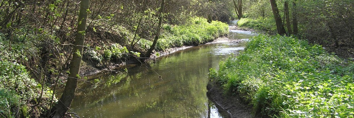
Outdoor area of the Werse
After a rainfall event limited to the area of Ahlen - Dolberg - Beckum, which according to statistics only occurs every 250 - 500 years with rainfall amounts of more than 100 litres in two hours, large parts of the Werseniederung and the coal mine settlement in Ahlen were flooded from 3 to 6 May 2001.
After the immediate measures of help for those affected on site, it quickly became clear that flood protection measures were required for the city of Ahlen as a whole. The city of Ahlen itself very quickly implemented many of the safety measures to be implemented locally in the city area. However, it became clear that an overarching concept for the entire upper reaches of the Werse, including Beckum, is necessary for sustainable flood protection.
Concept
This concept was drawn up in 2002 by the district of Warendorf in cooperation with the State Environmental Agency of Münster (now the District Government of Münster) and the towns of Ahlen and Beckum by a specialist office. The entire Beckum - Ahlen area with a surface of approx. 48 km² was investigated. The aim was to protect the settlements of Ahlen and Beckum against flooding and at the same time to improve the ecology and develop the Werse from Beckum to Ahlen in a near-natural way.
Based on comprehensive water management and landscape ecology analyses, the following situation emerged:
- For the settlement location of Beckum, there is no flood hazard for the "100-year flood event" (HQ 100).
- Even taking into account the "immediate measures" for flood protection in the settlement area of Ahlen, flood areas exist in the built-up area of the city of Ahlen in the event of HQ 100.
- The implemented and planned emergency measures increase the flood risk for downstream residents. This aggravation must be compensated by appropriate measures.
- Sustainable development of the Werse, which takes into account both flood protection concerns and the requirements of the EC Water Framework Directive, can be established on the Werse between Beckum and Ahlen by creating near-natural retention areas (with a retention volume of approx. 350,000 to 400,000 m³).
- As a result, local protection measures are only required to a minor extent and can be compensated with regard to the impact on downstream riparians.
The planning of the overall measure, including the water law permit and an environmental impact assessment, was carried out for section A4b in 2004 and for the other sections in 2008. This required extensive land acquisition in some cases. The planning showed that instead of the originally planned reactivation of the primary floodplain, a deeper secondary floodplain had to be created. As a result, the amount of land required could be greatly reduced in favour of agriculture. The newly created floodplain is now flooded even during minor rain events. This significantly slows down the runoff velocity and retains the water.
After initial revegetation, the new Werse can develop largely independently and close to nature into a floodplain forest with open spaces. The areas above the floodplain are transformed into extensively used open spaces with individually interspersed woody plants. The areas will be grazed by a flock of sheep.
The Werser cycle path must be partially relocated, but it will remain alongside the stream to provide interesting views of the near-natural floodplain landscape.
The state of North Rhine-Westphalia provides 80 % of the funding for the measures. The remaining 20 % will be refinanced through the municipal eco-account.