

- City Hall & Service
- Learning & Togetherness
- Living & Future
- Discover & Experience
Implementation of the Flood Management Directive in Beckum
Mastering flood risks together
Floods are natural phenomena that will in all likelihood increase rather than decrease in the future. We have to deal with this.
The flood risk management plans published on 22 December 2015 summarise and document for NRW what the many stakeholders involved contribute and want to contribute in the future to reducing risks from flood events. This continues the flood protection and flood prevention activities that have existed for many years at all levels of the state and expands them in the sense of comprehensive management to deal with the risks.
The objectives of flood risk management are to
- the avoidance of new risks,
for example by preserving floodplains and retention areas and avoiding the creation of new damage potentials in flood-prone areas; - reducing existing risks,
for example by expanding retention areas and improving the resilience of important buildings and facilities; - the reduction of adverse consequences during a flood event,
for example through appropriate preparations that allow for a quick and adequate response; - the reduction of adverse consequences after a flood event,
for example through appropriate preparations and precautions that enable the damage to be remedied quickly and limit financial losses.
To this end, at the regional and local level, stakeholders from a wide range of disciplines such as water management, spatial planning, urban land use planning, supply and disposal, monument protection, disaster control and the economy have jointly put together a package of measures and documented them in the flood risk management plans. In accordance with the requirements of the Directive and the Federal Water Act, the extent to which the implementation of the measures has progressed and which further/new measures are required to achieve the objectives is now reviewed and recorded every six years.
An important basis for all actors and for every individual are the flood hazard and flood risk maps, which enable everyone to assess the individual hazard situation and implement preventive measures to reduce damage.
Detailed information on the measures planned, in the process of being implemented or already implemented can be found in the fact sheets prepared for each municipality in addition to the flood risk management plans. The municipal fact sheets contain all measures relevant for the area of the municipality. Not only measures of the municipality itself are listed, but also those of the Land (preparation of brochures, etc.) and other actors such as regional planning (consideration of flood prevention in the regional plan).
Flood risk management in Beckum
The Münster district government has been working on the implementation of the directive since 2010. The hazard and risk maps were coordinated with all stakeholders involved and finalised in December 2015.
The maps can be found under the above link in the Ems sub-basin and are subdivided according to the respective frequency of a possible flood.
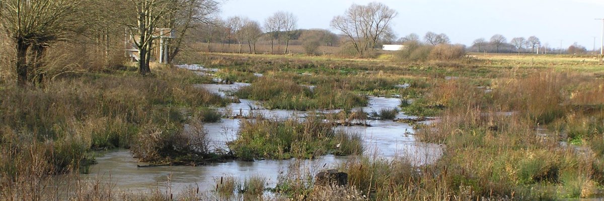
Two risk areas were identified in the city of Beckum: One area on the Werse in the eastern inner city area, a second in Neubeckum on the Hellbach in the area of the Eternit/B 475 company premises.
A programme of measures has been drawn up for both risk areas to reduce the risk of flooding. The resulting constructional requirements are integrated into the measures already taking place to implement the Water Framework Directive on the Werse and Hellbach watercourses and successively implemented.
Risk area 1: Werse Beckum, eastern city area; section Sternstraße to Kindergarten/Südwall
Flood safety is guaranteed in this area up to and including a hundred-year flood. This corresponds to the legal requirement. However, in the event of an extreme flood, parts of the eastern inner city may be under water (see hazard and risk maps).
In the upper reaches, flood protection measures have already been implemented. Currently, the focus of planning is on the actual risk area. Particular importance is attached to optimally combining the requirements of the Water Framework Directive with those of flood protection.
Currently, a rainfall-runoff model is being created, with the help of which the current weak points of the water flow can be determined from the point of view of flood protection. Based on this, structural measures can be taken to increase flood protection for the eastern inner city. These measures can include, for example, the strengthening and raising of the walls towards the city centre or - if possible - the widening of the Werse and Kollenbach. Between the "Altes E-Werk" youth centre, which was also affected, and Sternstraße, the Kollenbach, which was previously partially piped, was opened up.
Risk area 2: Hellbach, Eternit/Dyckerhoffstraße (Am Volkspark to Kaiser-Wilhelm-Straße)
Flood safety for a hundred-year event is only partially guaranteed at this location: In this case, parts of the company access road and the main road could be under water, as could parts of Kaiser-Wilhelm-Strasse. In the event of an extreme flood, the flooded areas will continue to expand, and the Eternit factory premises in particular will be significantly affected.
Preliminary plans have already been made for the near-natural development of the Hellbach river, taking flood protection into account at the same time. In the upper reaches, flood protection measures have already been implemented. Further construction work in the lower reaches is currently being prepared.
In the area of the B 475 and the Eternit company, there is the possibility of significantly improving flood protection by opening up the Hellbach, which is largely piped at this point. This requires coordination with the respective owners in order to jointly develop and implement a solution.
Further risk provisioning
Beyond structural precautions, many other measures are possible and necessary to achieve the best possible protection. Here, the municipality is also dependent on the cooperation of the respective owners in terms of their own precautions. Questions of building precautions and advice (e.g. on oil tanks), monument protection, private and commercial property protection, e.g. with regard to insurance, public relations work and awareness raising, local hazard prevention by the fire brigade, the Federal Agency for Technical Relief and the German Red Cross and disaster control are relevant in this respect.